navigator.berlin · Beta
Berlin in data.
Enter an address. See how loud it is, how hot it gets in summer, how close the nearest S-Bahn station is. Combined into a Kiez score across five dimensions.
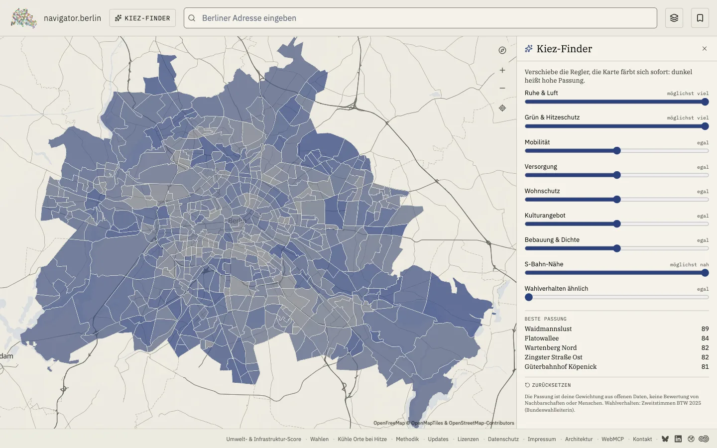
New · Kiez Finder
Tell the map what you're looking for
Nine different, combinable sliders to help you find your ideal Bezirk or Kiez.
- „quiet and good air"
- „S-Bahn not far"
- „lots of green, little hustle"
- „good amenities in the Kiez"
The map doesn't judge neighbourhoods or people, it only shows how well an area matches your sliders.
Enter an address. Combine the data.
Noise level per street. Heat class per Kiez. Public transport density per Bezirk. Values from the Senate's open data. Compare addresses and Kieze directly. For the flat hunt, the move, the research, or the next argument at the kitchen table.
Open map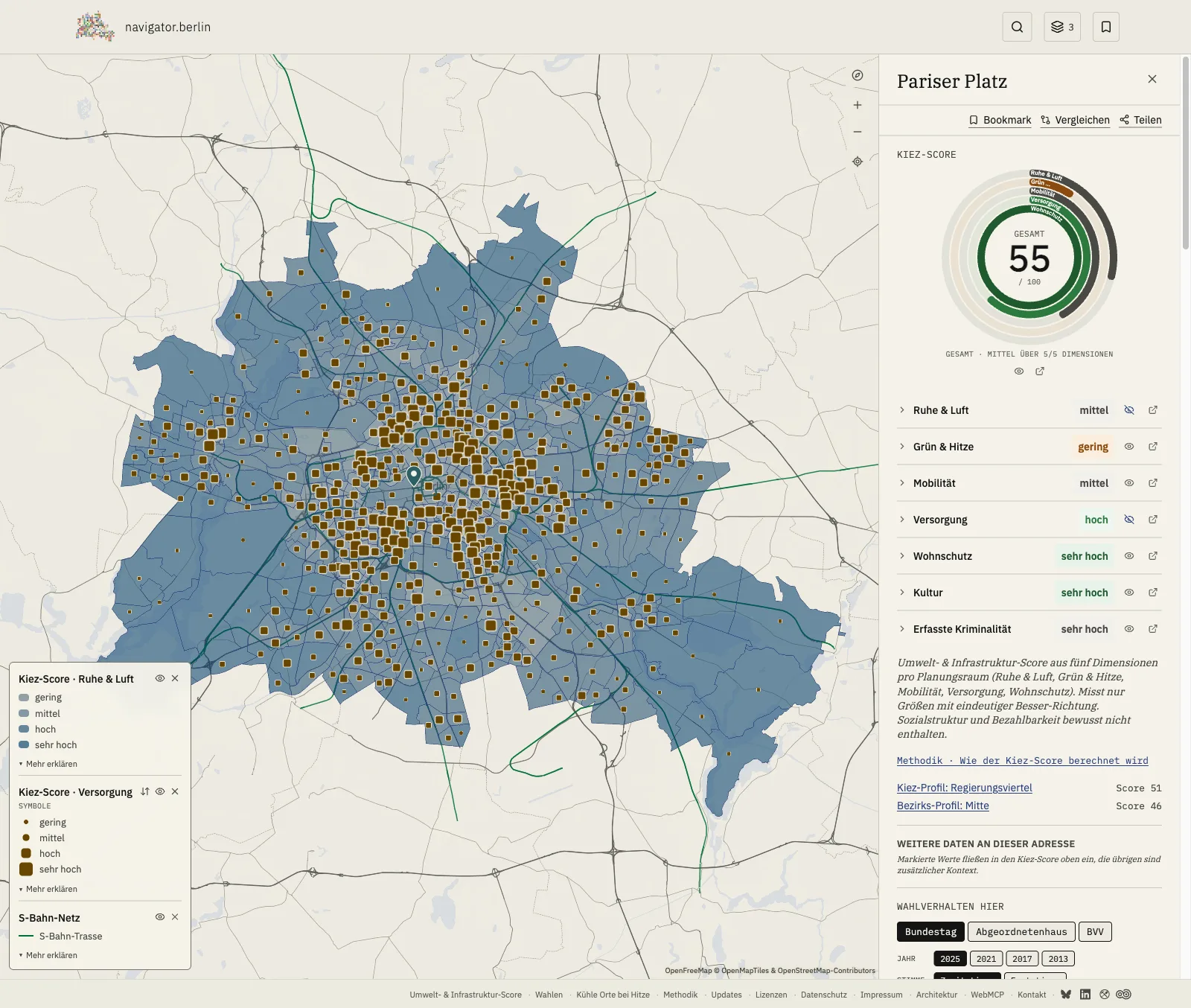
In three steps
- Step 1
Choose an address or Kiez
Enter a Berlin address or click a Kiez on the map.
- Step 2
Kiez score & dimensions
A Kiez score from 0 to 100 across five dimensions. Culture and crime are added as context.
- Step 3
Compare layers
Switch individual data layers onto the map and compare addresses, Kieze and Bezirke directly.
Five places to start
One click opens the map at that point, with all data layers next to it.
Elections since 2011
Bundestag, Berlin House of Representatives (Abgeordnetenhaus), District Assembly (BVV). The strongest party per address, a polling-district map with 3,500 polygons, the trend over recent years per Kiez.
- party vote · Provisional House of Representatives 2026 Source Berlin State Election Commissioner (Landeswahlleiterin Berlin)
- vote · Provisional District Assembly (BVV) election 2026 Source Berlin State Election Commissioner (Landeswahlleiterin Berlin)
- party vote Bundestag election 2025 Source Federal Election Commissioner (Bundeswahlleiterin)
New · in hot weather
Cool places in Berlin
Over 500 cool places in hot weather: cinemas, libraries, swimming pools, museums, malls and drinking fountains. With address, live status and directions. Built on open data.
12 Bezirke
Per Bezirk: profile, Kiez score and answers to the most common questions. Four entry points here, all twelve reachable via search.
- Mitte Government district, Alexanderplatz, Wedding. The widest range between high politics and the tenement block.
- Friedrichshain-Kreuzberg The city's densest population. Noisy, young, in flux.
- Pankow From Prenzlauer Berg to Buch and Französisch Buchholz. Neighbourhoods with very different conditions.
- Neukölln From Reuterkiez to Rudow. The stage for almost every Berlin debate on housing and urban development.
Every Kiez, one Kiez score across five dimensions
View ranking- 1 Südliche Luisenstadt · Friedrichshain-Kreuzberg 64
- 2 Frankfurter Allee Nord · Friedrichshain-Kreuzberg 60
- 3 Helmholtzplatz · Pankow 59
- 4 Prenzlauer Berg Südwest · Pankow 58
- 5 Südliche Friedrichstadt · Friedrichshain-Kreuzberg 58
Five equally weighted dimensions make up the overall score (0-100). Culture and recorded crime are added as standalone context but don't feed into the score. Describes distribution, not a rating of individual addresses or people.
71 data layers
Seven shown here in short, including the new context layers culture and crime. Each layer has its own detail page with methodology, licence and last-updated date.
- Noise 2023 Strategic noise mapping for Berlin. Ordinal categories per planning area instead of dB point values.
- Green space supply 2023 Green space near housing per person, classified per planning area. Senate Department for Urban Development.
- Climate PET 2022 Perceived midday temperature on summer heat days from the Berlin climate atlas.
- Mobility score Bus, tram, U-Bahn, S-Bahn and cycling infrastructure combined into the mobility dimension of the Kiez score.
- Housing locations 2024 Housing-location class from the Berlin rent index procedure (simple / medium / good), block-accurate.
- Culture Access to libraries, theatres, museums, cinemas and more. A standalone dimension, not part of the overall score.
- Recorded crime Police frequency rate per Bezirksregion. Context, not a safety judgement, not part of the overall score.
Latest updates
All updates- Feature 22 Aug 2026 Kiez Finder: tell the map what you are looking for Nine sliders instead of a search box: weight quiet, green space, S-Bahn proximity or voting behaviour, and the map recolours all 542 planning areas live.
- Feature 22 Aug 2026 Several map layers at once, finally readable Each score dimension has its own colour, a second layer appears as size symbols, and roles can be swapped. Plus: a new logo.
- Data update 08 Aug 2026 Cool places: 18 open churches added, Passionskirche first 18 verified open churches and one neighbourhood centre join the map. New figures: 491 cool places open in summer, 298 free of charge.
6 core sources
All from public datasets with an open-data licence. No scraping, no subscription, no advertising.
ODIS Berlin
Open Data Information Office · Bezirk and LOR geometries.
dl-de/zero-2-0
SenMVKU · Umweltatlas
Noise mapping, climate atlas, green space supply, bioclimate.
dl-de/zero-2-0
OpenStreetMap
Address geocoding, POI data, public transport stops and networks.
ODbL 1.0
DWD · Climate Data Center
Historical climate time series from Berlin's weather stations.
CC BY 4.0
SenStadt · Mietspiegel
Housing locations 2024 + Monitoring Social Urban Development 2025.
dl-de/zero-2-0
Geoportal Berlin · FIS-Broker
Heritage database, urban land-use planning, land values.
dl-de/zero-2-0